Legal Description Plotting and Mapping Software from Sandy Knoll Software, LLC.

Metes and Bounds

Metes and Bounds, by Sandy Knoll Software, LLC, is simply the best choice for legal description plotting software. Trusted by Landmen, Realtors, Homeowners, Genealogists, and various Legal Professionals, it offers outstanding features and a user-friendly interface. Available on Windows, Mac, and iOS, Metes and Bounds is the top solution for all your legal description plotting needs.

Desktop Features

Desktop Free, Basic and Pro Feature Comparison


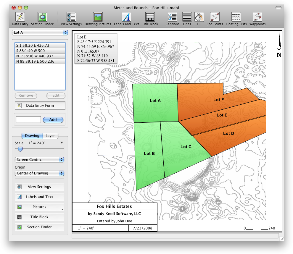
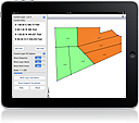
Turn legal descriptions into a map drawing.

Small Legal Description Plotter and Legal Description Mapping Software.

(click screenshot to enlarge)

Easy to use data entry form. Enter lines, curves, azimuths, compass points and section calls. Data can be entered using the convenient Data Entry Form or freehand using word processor style entry. Legal Description plots can also be easily drawn using the call drawing tool.

Customizable Toolbar: Create an interface that fits to your workflow.

Layers: Layers allow you to have multiple legal descriptions plotted on a single drawing. Layers can be free floating or locked to a common starting point.

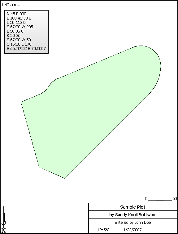
Perform plot calculations: Square Feet, Acres, Hectares, perimeter distance and more.

Metes and Bounds will calculate if the survey closes or not. Calculate closure errors: closing error ratios and the call needed to close the plot. Apply Compass Rule Adjustments.

The legal description plot closing error analyzer tool can look for common entry or survey errors and offer suggestions on how to correct them.

Auto-Completion of drawing. If you're missing the final segment of your land plotting data, let our Metes and Bounds - Legal Description plotting program finish the mapping for you. Determine closure errors. Have a bad or missing call? Enter a question mark (?) for the call and let the legal description plotting software find the missing call for you. Close drawings using Bearing-Bearing Intersections and Distance-Distance Intersections.

Multiple measurement types: Data can be inputted using Feet, meters, rods, chains and many other different measurement types. There should be a measure type for any of your real estate measurement needs.

Merge Layer: Layers can be easily merged into a single layer using the Merge Layer Tool.

Calculate a Legal Description's area and perimeter distance.

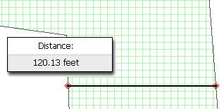
Easy to use measuring tool. Measure the distance between any two points on the screen.

Legal Description Plotter and Mapping Measuring Tool Image 1.

Automatic labeling: Each line can be automatically labeled with the length and call. End points can be marked for easier recognition. End points can also be labeled with information like the interior/exterior angles and Lat/Long coordinates.

Create custom labels and. Custom labels can be rotated in any direction. Search feature can be used to find which layers contain which labels.

Drawings can include a call list:
Legal Description Plotter and Mapping Call Lists.

Background Pictures. Background pictures can be set to scale with your plot drawing. Background picture scale settings can be automatically set using World Files.

Custom X,Y points. Use custom X,Y points to mark and label unique land features on the legal description plot.

Subdivide a single plot into multiple plots. Split the plot by hand, or choose a starting point and let the plot plotting software find the nearest halves automatically for you.

Printing: Legal Description plot printouts can include borders, north arrow and title block.

Create section drawings:

Legal Description Section Finder Plotter and Mapping.
(N 1/2 of the NE 1/4 of the SE 1/4)

Interoperability:

Metes and Bounds legal description plotter has been designed to be as compatible with as many different systems and programs as possible.

Exporting: Legal description data can be exported as DXF files, KML Files, CSV files, Shapefiles(.shp) and more.

Importing: Deed plotting data can be import from many types of DXF files, KML files, CSV files, Shapefiles(.shp), GeoJSON and more.

Call lists can be formatted for importing into Metes and Bounds or exporting from Metes and Bounds with other legal description plotting software such as Net Deed Plotter® by Greenbrier Graphics, LLC.

Real-world X,Y coordinates. Export real-world X,Y coordinates for integration with other mapping software such as GIS software.

Waypoints to metes and bounds calls. Convert a set of waypoints, x/y or Latitude/Longitude based, into a list of metes and bounds calls.

Enter Waypoints and Tracks. Add GPS waypoints and tracks to your legal description plots. Import GPX and KML files. Calculate things like the distance between two waypoints.

Real-world Latitude and Longitude coordinates. Enter the latitude and longitude for a plot's POB and let the legal description plotter calculate the latitude and longitude for each of the other end points.  A plot's POB lat/long can also be set by UTM datum or World Files.

Recognition:
Metes and Bounds can be found in Genealogy Online For Dummies. -  5th Edition, by Wiley Publishing.

Download Our Desktop Legal Description Software
Download includes the Pro, Basic and Free editions.

Functionality is determined by your serial number.
No serial number is required for the Free edition.

Legal Description Plotter and Legal Description Mapping Software Image 1.

Download OSX Legal Description Software

Download Windows Legal Description Software.
Windows

Download Legal Description Software for Mac
Mac OS X 10.10.5 or Higher
64-Bit

Download Legal Description Mapping Software for PC
Windows 7 SP1 or Higher

Download old versions

Change History


Desktop Features

Desktop Free

Desktop Basic

Desktop Pro

Auto Complete Drawing Metes and Bounds Feature Auto Complete Metes and Bounds Software Auto Complete Metes and Bounds Software Auto Complete
Line Call Captions Metes and Bounds Software Line Call Captions Metes and Bounds Software Line Call Captions Metes and Bounds Software Line Call Captions
Custom Scales Metes and Bounds Software Custom Scales Metes and Bounds Software Custom Scales Metes and Bounds Software Custom Scales
Call Lists on Drawing Metes and Bounds Software Call Lists Metes and Bounds Software Call Lists Metes and Bounds Software Call Lists
Plot Splitting   Metes and Bounds Software Plot Splitting Metes and Bounds Software Plot SplittingMetes and Bounds Software Plot Splitting
DXF Export   Metes and Bounds Software DXF Export Metes and Bounds Software DXF Export
Scaled Background Pictures   Metes and Bounds Software Scaled Background Pictures Metes and Bounds Software Scaled Background Images
Measurement Tool   Metes and Bounds Software Measurement Tool Metes and Bounds Software Measurement Tool
Area Calculations   Metes and Bounds Software Area Calculations Metes and Bounds Software Area Calculations
Endpoint Calculations   Metes and Bounds Software Endpoint Calculations Metes and Bounds Software Endpoint Calculations BasicMetes and Bounds Software Endpoint Calculations Pro
Title Blocks   Metes and Bounds Software Title Blocks Metes and Bounds Software Title Blocks
Analyze Closing Errors     Metes and Bounds Software Analyze Closing Errors
Multiple Layers/Tracts/Plots     Metes and Bounds Software Multiple Plots
Curve Calls     Metes and Bounds Software Curves
Lat/Long, GPX, KML, Shapefiles(.shp)     Metes and Bounds Software Export KML and Shapefiles
Correct Bad or Missing Calls     Metes and Bounds Software Find Missing Calls
Call Drawing Tool     Metes and Bounds Software Call Drawing Tool
Section Maps 1 1 36

Buy Metes and Bounds - Legal Description Mapping Software

Free Edition

Free

Click one of the Download buttons above.

Basic Edition
Does not include curves, multiple layers or waypoints.

$39.95

Buy or Shop for Legal Description Mapping Software.
Includes 1 year of updates from date of purchase.

Basic to Pro Upgrade
Add curves, multiple layers and waypoints. This option requires that you already own the Basic edition.

$40.00

Buy Legal Description Mapping Software Now.
Includes 1 year of updates from date of purchase.

Pro Edition
Includes all features.

$79.95
Volume Discounts Available

Buy Legal Description Mapping Software Today.
Includes 1 year of updates from date of purchase.

1-Year Update Renewal
Allows access to all updates for 1 year from date of this purchase. Updating is optional.

$29.95

Buy this for computers.

Purchase serial number to unlock the Pro edition of Metes and Bounds

Sandy Knoll Software, LLC Support FAQ:
Download/Install/Uninstall Information

For more information, email: support@sandyknollsw.com


Also see our tutorial and video section.

Mobile Legal Description Plotting Software

Mobile Feature Comparison

Basic
for iPhone, iPad, and iPod touch

Pro
for iPad

Auto Complete Drawing check check
Labeling   check
Multiple Layers/Tracts/Plots   check
Curves check check
GPS check check
Section Maps 0 1
iPhone land plotter. Basic for iPhone, iPad, and iPod touch
v1.9.4
Designed for iPhone and iPad. Does not include many of the features listed on this page. Please see iOS Basic edition website for feature list.
$4.99 Appstore land plotter.
iPade land plotter. Pro for iPad
v1.6.3
Designed specifically for the iPad. Does not include many of the features listed on this page. Please see iOS Pro edition website for feature list.

$9.99

iOS pro land plotter.


Sample Legal Description Plotter Output

Legal Description Plotter and Mapping in Google Earth.
KML Output viewed in Google Earth

DXF Legal Description Plotter and Mapping Software Export.
DXF Output viewed in a CAD program


Metes and Bounds Legal Description Mapping Software

Metes and Bounds (our real estate deed drawing software) is Copyright © 2001-2023 by Sandy Knoll Software, LLC. Try our deed plotting software for free.
Terms and Conditions/EULA

Apple, the Apple logo, iPod, and iTunes are trademarks of Apple Inc., registered in the U.S. and other countries. iPhone is a trademark of Apple Inc.
For Dummies® is a registered trademark of John Wiley & Sons, Inc., which does not sponsor, authorize, or endorse this website or the products of Sandy Knoll Software, LLC.
NET DEED PLOTTER® is a registered trademark of Greenbrier Graphics, LLC, which does not sponsor, authorize, or endorse this website or the products of Sandy Knoll Software, LLC.
Portions of this page are reproduced from work created and shared by Google and used according to terms described in the Creative Commons 3.0 Attribution License. Android is a trademark of Google Inc.
The Windows logo is a registered trademark of Microsoft.